
Foreword.
Introduction.
Archaeological Approach.
Observations.
Figures:
Foreword:
This archaeological report has been compiled at the request of the Mindi Mindi Corporation on behalf of Tanba 'Jiddngarri' Banks, elder and traditional owner for the Bungle Bungles.
The Jaru word for the Bungle Bungle Range is Billingjal, but for the purposes of this report I have continued to use the more common name for the area.
My fieldwork in the Bungles began almost seventeen years ago. During this time I have been privileged with stories and information about the Aboriginal history of the Bungle Bungles from many Aboriginal people. Tanba Banks, for whom this report has been requested, has shared with me some of her wonderful history and cultural connection to the Bungle area. I have spent many rewarding occasions with Tanba, her family and other members of the Jaru Language Group. Their pleasure and delight in talking about their history and sharing their stories, introduced an immense richness to the archaeological and scientific evidence.
I have not however, used the information shared by Tanba or other Aboriginal people in this report. The following report is purely a scientific assessment of the archaeological data recorded by the author. Much of the following archaeological data is also available in two previous reports produced by the author.
More recently, Tanba and members of her family and other Jaru representatives have allowed their stories and their history to be formally recorded by Anthropologist Janelle White (2001:Jaru Oral History Project Report). Her report is available on request of Elder and traditional owner Tanba Banks. Anthropologist Dr Fiona Powell has also been working with Tanba and her family. Introduction.
The archaeology of the Bungle Bungles is extraordinary for its richness and diversity of rock art and other types of archaeological sites. There are over 300 occupation and rock art sites evident throughout the Bungle Range. Each site, like part of a giant jigsaw puzzle, provides insight into the activities of Aboriginal people who used some areas primarily for hunting and gathering, and others for teaching, ritual, and spiritual ceremonies.
The archaeological information can provide some insight into the mythology of the area. However, it is the rich oral traditions of Aboriginal people which provide the living evidence without which the scientific analysis remains entirely speculative.
Whilst the present generations have never lived exclusively in the area by hunting and gathering, considerable mythological information has been passed on. Many of these descendants have began to return to the Bungles to regain their strong cultural ties to the area.
The archaeological analysis of rock art and other physical past human activity can never provide a full understanding or insight into the people who once lived and exploited the resources of the Bungle Bungle area. However, it can assist in providing a ( somewhat dry and sterile) insight into what might have happened long ago. Often this is all the information that is left for sites that may be thousands of years old. For this reason it is intended that this report be seen as more of academic interest to the descendants rather than an intrusion or misconception of the stories and information that have been handed down to them today.
The geology and biodiversity of the Bungles changes significantly from the east to the western areas of the massif, and from the northern perimeters to the southern areas making up the beehives. The top of the massif is different again. The archaeological evidence indicates both the geological features and the range in biodiversity impacted on how, and in what way the Bungles were used by Aboriginal people at the time. The location of easily accessible water also appears to have influenced early Aboriginal use. The archaeological data indicates that over the tens of thousands of years the Bungles were used by Aboriginal people, cultural boundaries may have changed, and that at times there was even overlapping of use by groups of some areas. This may very well have been influenced by climatic variations and changes, which in turn would have impacted on the extent and availability of resources throughout the Bungle area.
It must be pointed out that the above criteria does not appear to have applied to choices made by Aboriginal people after European impact. During this period the criteria used by Aboriginal people for use of an area changed. The wet season was the only time that Aboriginal people who were living and working on a cattle station could return to a semi traditional lifestyle. Areas that may have only been dry season camps previously were being used in the wet and for different purposes. In many parts of the Kimberley, cattle station life introduced Aboriginal people into areas that their descendants might never have gone into. This also meant the pastoral era had profound impact on Aboriginal stories and memories of their more traditional cultural heritage and history. The archaeological evidence of the Bungle Bungles does provide some insight into what impact Europeans and the pastoral industry had on Aboriginal activities and culture, however that story is better told by Aboriginal people themselves.
The following then, is essentially an archaeological story. It is an interpretation of the physical evidence left behind by people who used the Bungles over thousands of years. It is not meant to be a comparative interpretation of either the ethnographic information available or of the rich oral traditions and stories still very alive in Aboriginal culture today.
1. The Beehive Area.
The beehive area, located to the south of the Bungles massif, and so named because of its dome like formations, is extraordinarily rich in archaeological sites, indicating intensive Aboriginal use over thousands of years.
The archaeological evidence indicates the beehive area in general may have experienced a difference in use, or 'perception of use' by Aboriginal people to other areas in the Bungles. .There is also some evidence of cultural overlapping into other areas within the Bungles suggesting that at times, those people exploiting the resources of the Beehive's also ventured further north towards the conglomerate zone. A strong cultural desert influence is present in much of the rock art recorded in the Beehive area, and this influence can be observed in some of the rock art sequences recorded in the northern conglomerate sections of the Bungle Bungles. There is little archaeological evidence however, in the rock art recorded in the Beehives of any cultural influence from groups primarily exploiting the northern areas of the Bungles. The definitive 'cut-off' point for Aboriginal groups moving from the conglomerate zone south along the western face of the Massif to the Beehive area appears to be around Deep Gorge (see section on Deep Gorge).
The rock art sites recorded in the Beehive area are extremely fragile, and generally in a very poor state of preservation due primarily to the fragile nature of the sandstone in this area. Rapid erosion is taking pace through natural factors such as wind, water and animal activity. In more recent years this natural deterioration has been accelerated by the impact of fire on the rock art. Feral donkey tracks running parallel to many of the art site rock overhangs assisted in the past to keep the fire away from the rock face (personal observation by the author). With the removal of donkeys from the Bungle Bungle area and a change in the vegetation structure in more recent years, fire is now having a direct impact on the rock art. However, it is also apparent that many of these sites are of considerable age. Time as well as the elements are steadily having their impact. The archaeological evidence indicates that Aboriginal peoples traditional activities may have ceased in the Beehive area at or around the time of European impact. The one exception to this is a site commonly referred to as Bat Cave, located in Piccaninny Creek. There are several children's handprints placed over considerably older motifs. These still retain a slight residue ochre on the surface of the rock and appear to be relatively 'recent'. The age of these is uncertain, however, they are considerably younger than the red infill painted motifs beneath them..
The rock art in general in the Beehive area shows considerable variation in motif and style, and indicates several superimposed sequences of rock art activity. By far the most dominant style of painting in the Beehive area is the red infill ochre motifs.
1a. 'Ritual' or Ceremonial Figures?.
The archaeological evidence suggests that the beehive area changed dramatically and suddenly in 'perception of use' by Aboriginal people around the time of European impact. The beehive area appears to have changed in use from traditional activities associated with family and hunting groups to an area that seems to have taken on a different perspective. The rock art associated with this change indicates a ritual or spiritual significance for the area taking the place of ordinary family activities.
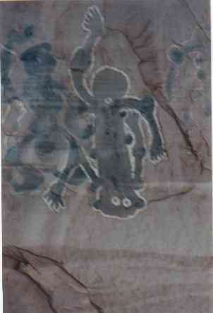
|
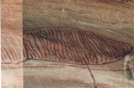
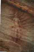
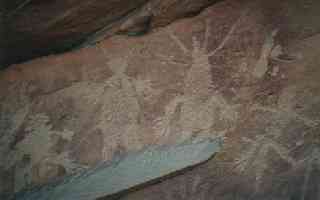
This later dramatic change in rock art style and technique was determined as being more 'recent' and a new development in rock art in the beehive area. Only two sites were selected for this change. These sites are both located in very prominent geological features, and face the beehive area from the eastern and western perimeters of the domes. Both sites are dominated by large 2 meter charcoal infill and white ochre anthropomorphic 'ritual' or ceremonial figures in both the upside down position and standing (See fig. 1). A 'ceremonial' burial recorded by the author and located between these two 'spiritual' sites may also belong to this later phase of rock art. The bones have been painted in ochre and carefully wrapped in paper bark and placed in a half sitting position facing the western sun. The burial is in a prominent high spot and can be seen easily from both locations. Further archaeological work is required before any further hypothesis can be made. Archaeologically, these figures show a very strong desert influence. The figures stylistically represent the typical ritual or 'spiritual' warning spirit figures similar to those found in the Pilbarra desert area and north east from the Bungles area into the desert area of the northern territory (personal observation.). |
Stylistically and technically, the anthropomorphic figures may indicate the work or influence of an overlapping separate cultural group. On the other hand, they may also represent a cultural response to a social and economic change such as that experienced by Aboriginal groups throughout Australia during initial European impact.
It is difficult archaeologically, to determine with any degree of confidence what the artists were attempting to portray. The painters however, do not appear to have had the time to complete their work? Several anthropomorphic figures are incomplete, with only the white ochre outline in place. The anthropomorphic figures show no evidence of previous painting, or evidence of repainting.
1b. Aboriginal Family Living Sites?
Ninety eight percent of the sites surveyed in the Beehive area were archaeological sites interpreted as those to be typically associated with groups using the area for general living purposes. Many of the sites show wonderful examples of an older generation teaching the younger members about 'country'. Painted and engraved motifs clearly define various food resources found in the area, hunting methods and the general topographic 'maps of country'.
|
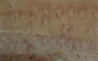
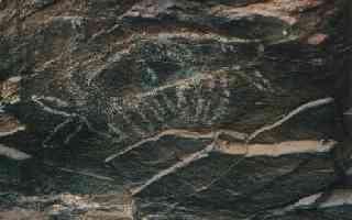
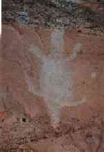
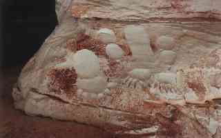
One area of the beehives, and colloquially referred to as the 'stadium', contains a tremendous gallery of hands (adults and children), feet boomerangs, spears, plant images and other stencils (see fig 2). Almost every conceivable protective rock overhang in this 'shoe' shaped area contains rock art showing every day survival, 'teaching', ceremonial and hunting type activities. 1c. Abraded and engraved motifs. One area of the beehives, and colloquially referred to as the 'stadium', contains a tremendous gallery of hands (adults and children), feet boomerangs, spears, plant images and other stencils (see fig 2). Almost every conceivable protective rock overhang in this 'shoe' shaped area contains rock art showing every day survival, 'teaching', ceremonial and hunting type activities. 1c. Abraded and engraved motifs. |
|
Abraded and engraved motifs and 'spear' cuts make up a significant component of the sites recorded in the beehives. The precision, patterning and quantity of 'cuts' found in some of the sandstone overhangs suggests that the activity is probably related to 'increase' ceremonies. The author has recorded the same phenomena in other areas of the Kimberley, and has determined that this precise and even patterning of engraved 'cuts' indicate a ritual purpose generally associated with a ceremonial increase. When associated with a food resource, such as wallaby or emu, the author has recorded painted or carved footprints of the animal involved.
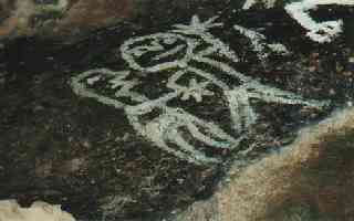
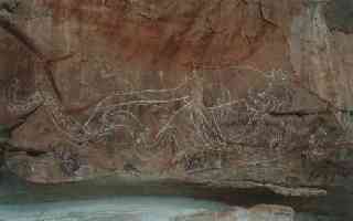
Only a handful of sites showed any evidence of the later se quence of the earliest phase of white ochre outline painted motifs. This phase is generally associated with a period of time just prior to European impact. One of these sites show large white ochre outlined representations of two Platypus, an aquatic creature no longer found in the Kimberley (See figure 3). This aquatic marsupial has not (to the authors knowledge) been officially recorded in the Kimberley since European contact.
|
The presence of the platypus in what is now a predominantly semi arid dry area, indicates the Bungles may have been a lot 'wetter' at one time, with the immediate creek systems in and around the Bungles quite different to their annual and spasmodic flow of today. A further hypothesis suggests the paintings may have been done by an Aboriginal individual describing what he had observed elsewhere. The last known sighting of a platypus anywhere near the Bungles was in the Osmonds, north east of the Bungles Range (personal comment to the author by Mr. Jack Green, now deceased). It is not known whether Mr. Green was referring to the fact that he had actually sighted the platypus, or had only heard about the incident. |
General archaeological Conclusions for the Beehive area of the Bungle Bungles.
The archaeological information recorded for the Beehive area, indicates that at some time either just before, or around the turn of the century, the beehive area underwent a major cultural change. That is, evidence of a major change in the perception of Aboriginal use of the area. The archaeological evidence indicates Aboriginal groups exploited the beehive area for food resources, ceremonies and other cultural activities for hundreds, possibly thousands of years, with one area, the 'stadium, showing evidence of large gatherings of family and hunting groups. Then suddenly, for whatever reason, social, economic, political or spiritual, these activities appear to have ceased, and the beehives seemed to become an area for people to avoid
The archaeological evidence indicates that there may have been some 'overlapping' of various cultural groups in the beehive area over time, particularly those sites showing desert influence in the rock art. However, this evidence is not as clear for the beehive area as in other parts of the Bungles and may be interpreted as an indication of changing ideas within the cultural group exploiting the area through time.
The large white infill, charcoal outlined anthropomorphic spiritual 'ritual' or ceremonial figures are probably more 'recent' than the dominant red ochre infill motifs, or any of the sites associated with 'increase' ceremonies and other Aboriginal group activities. The archaeological evidence indicates that those sites pertaining to everyday Aboriginal activity suddenly ceased, suggesting that an abrupt change took place in the perception of the use of the beehive area by Aboriginal people, probably around the time of the painting of the large anthropomorphic figures.
The silica buildup or desert varnish, considered to be a slow process indicates many of the sites are very old. Faded red infill motifs, now represented only as a stain on the rock surface, also suggest many of these sites are very old.
The stylistic image and the technique used on engraved motifs indicate a strong desert influence or culture. This desert influence can also be observed in the stylistic variation of the large anthropomorphic figures found in two of the sites.
There is some archaeological indication that at one time the Bungle Bungle area may have experienced a 'wetter' and cooler climatic condition, with permanent creek systems running to and from the Ord. This is supported by the very distinctive ochre painted images of platypus found in the Beehive area.
The archaeological evidence indicates that groups exploiting the Beehive area also periodically exploited the resources of the Conglomerate area of the Bungles. There is however, little archaeological evidence that cultural groups using the area north of Deep Gorge also exploited the resources of the Beehive area.
In brief, the archaeological evidence points to a consistency of use of the beehive area for ceremony, hunting, teaching, and general living purposes for long periods of time. Just before or around contact, the area changed completely in perception of use, and appears to have become an area to avoid. The large dominant anthropomorphic figures appear to belong to this period of cultural change in the Beehive area. The Beehive area also indicates there has been a strong desert influence throughout it history of use by Aboriginal people.
The archaeological evidence indicates the Deep Gorge area seems to have remained an autonomous area with no changes in the rock art motifs or evidence of superimposition of art sequences over time (see below). This gorge is located approximately between that geological feature designated as the beehive area and the conglomerate area lying north of Deep Gorge. The archaeological evidence indicates this area may have been a cultural or linguistic 'boundary' at one time for Aboriginal groups exploiting the Bungle Bungles. Desert influence is evident in the style of the painted motifs found in this gorge.
Deep Gorge is the only gorge throughout the Bungle massif where the author has recorded sufficient archaeological evidence to indicate Aborigines ventured well into the depths of a gorge. Deep gorge however, is unusual for its openness and easy accessibility. The main rock art sites are located approx. 1.4 kilometres into the gorge. An archaeological survey beyond the recorded rock art sites failed to locate any further archaeological evidence of Aboriginal activity.
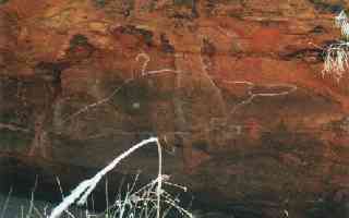
The three sites located within the Deep Gorge area appear to be ritual/ceremonial in nature (personal observation see fig 4). There is no archaeological evidence of lithic material or other signs of Aboriginal group of hunting activities. Ochre grinding hollows still retain ochre staining. An ochre stained grinding stone is also still in place in one of the sites. Apart from two sites suggesting group activity and located at the entrance to the gorge, there is no other evidence of rock art or other archaeological indicators of Aboriginal activity through the gorge until the three 'ceremonial' sites are reached. The very location and the unusual symbolic red ochre infill motifs indicate these sites were probably 'ritual' or ceremonial. The rock art images are now only represented as ochre staining on the rock |
|
General Conclusions for the Deep Gorge Area.
1. The archaeological evidence suggest that Deep Gorge was probably a 'ritual' or ceremonial area. The archaeological evidence also indicates that Deep Gorge may have been a 'demarcation' or cultural (linguistic) boundary at some period of time between Aboriginal groups utilising the Bungles resources. 2. The preservation status of these very protected red ochre infill images indicate the sites are very old and probably pre-date European contact. |
|
3. The North-West Area.
3a. Post Contact use of the Bungles
The northern end of the massif indicates strong archaeological evidence of continued activity well after European contact. This evidence appears to be restricted primarily to a small area located along the north western face of the massif, north of Deep Gorge, and east of the former |
|
Bungle Bungle Outstation.
Aboriginal stockmen and their families also used the limestone outcrop situated near the outstation for rock painting and other cultural activities. The rock art, metal and glass artifacts and other items embody both station life for Aboriginal people and the semi-traditional lifestyle they continued to lead during the wet seasons when mustering was completed.
|
|
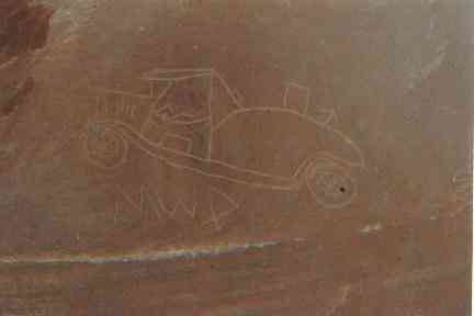
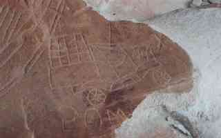
The main rock art site's associated with the station phase appear to be restricted to four main sites, three of which are located along the western face of the massif, with the remaining one located in the limestone outcrop. Rock art themes and motifs are focussed around station activities. Several engraved vehicle motifs relating to the 1930's/40's era of vehicle types, stockman like anthropomorphic figures, (one shaking hands with another) and pack animals such as donkeys and horses all make up the rock art images relating to Aboriginal pastoral station activity (see figs.6, 7 & 8).
|
The engraved images frequently have letters carved into the rock face, possibly signifying the names of the Aboriginal artists. (see fig 9.) The application or technique of 'engraving' rather than painting again appears to have been influenced by the desert technique of rock art. |
Tobacco tins, leather fragments, general tools of trade for the stockman and the presence of 'butchered' cattle bones etc all signify continued Aboriginal activity in this section of the Bungles, immediately adjacent to the outstation. |
|
3b. Pre-European use
The archaeological evidence for this area indicates the north western face of the massif and adjacent areas west to the Bellburn Creek area has always been a significant area for Aboriginal groups utilising the Bungles resources. The author has determined however, that there appears to be a gap in the archaeological information suggesting Aboriginal people may have stopped using this immediate area of the Bungles for a time prior to the Bungle outstation functioning in the 1920's.
The fine carefully applied stark white ochre outline animal and spiritual figures, often overlying each other, is common in the sites located along the north western face of the Bungles massif (see fig 11). The author has determined that this phase of rock art appears to belong to a pre European period of time. |
|
The application of heavy off white ochre infilled spiritual figures and other motifs usually found overlying the fine white ochre outlined motifs has not been recorded by the author in this area of the Bungles (see fig 12)
There are also a number of sites around the area adjacent the Bungle Bungle Station which show abraded, pecked and ground engravings of animal forms, spiritual figures and other engraved motifs (see figure 13). The style and technique again indicates there is a strong desert influence in the Bungle area in general and that this influence has continued over thousands of years. This technique of pecking images such as the ones recorded in the Bungles can be found as far as the Pilbara desert areas. |
|
There is little indication of a build-up of desert varnish, but this indicator alone does not always suggest a great age of antiquity. These figures, however are superimposed over the red ochre infill motifs, indicating a later phase of rock art. There is no way at present of determining just how old these superb engraved motifs are.
Up to six superimposed art sequences have been identified by the author in the rock art sites This is mainly perceived in the strong desert influence that appears in some of the sequences of superimposed layers of painted and engraved rock art images. |
|
General Conclusions for the North-West area of the Bungle Bungles.
1. The archaeological evidence indicates only a handful of sites in this area, and in the Bungles in general, continued to be used by Aboriginal people after European contact.
2. The technique of engraving the vehicle images or motifs show a desert influence, indicating the Aboriginal stockmen responsible for this rock art probably originate from the desert area.
|
3. The abraded and pecked anthropomorphic figures are unusual in that they are primarily associated with the north western area of the Bungles. These motifs suggest that desert influenced cultural activities continued for thousands of years in the Bungle area. 4. The many superimposed layers of rock art and changing techniques and art imagery indicate a dynamic changing cultural perspective and use by Aboriginal people of this specific area of the Bungles over thousands of years. |
In brief the archaeological evidence suggests that the north eastern area of the Bungles may have experienced many different cultural groups over thousands of years. There is also some evidence of an overlapping of cultural groups sharing the resources at the same time, and that at times the area changed dramatically in the perception of its use by Aboriginal people. Desert influence in the cultural activities over thousands of years through to well after post European contact can be observed in the rock art.
There is also some indication that there may have been a short period when Aboriginal people were no longer using this area, however the importance of this area to Aboriginal people is shown in the way it was used while the Bungle Bungle outstation functioned.
This strong cultural connection to the Bungle Bungles has been shown in more recent years, with various Aboriginal people re-establishing their ancestral and pastoral links to the area.
4. Red Rock and Buchanan Creek Areas.
Whilst this area has been designated as an archaeological 'whole' there is some variation in the rock art from the Red Rock Creek area to the stylistic variations recorded in the Buchanan Creek system. The author has not however, been able to interpret whether this change indicates a different use of each area by the same cultural group, or whether the sites actually represent quite different periods or overlapping of use by different Aboriginal groups.
|
The percentage of site's recorded in this general area is quite low in comparison to the number of sites located on the western face of the massif and in the beehive area. In general the sites recorded appear to indicate ceremonial purposes for Aboriginal groups rather than living areas. Two major engraved and cupule 'increase' ceremonial sites were recorded in the Bellburn Creek system. White ochre stick like figures found in the Buchanan Creek system are unlike any other anthropomorphic figures recorded elsewhere in the Bungles. It has been suggested they may represent star constellations because of their star like configurations (Cairns: pers.com. see fig 14). They appear to overlay very faded red ochre motifs, suggesting this particular site certainly changed in Aboriginal perception of use for the area. |
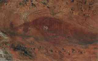
In general all the red ochre motifs, including two large crocodile images (see fig 15) are very faded and are little more than ochre stains on the rock surface, indicating great antiquity. Many of the red ochre infill images are unique to this immediate area in their stylistic variations.
General Conclusions for the Red Rock and Buchanan Creek areas of the Bungles.
|
|
In brief this area requires a great deal more archaeological fieldwork before any real conclusions can be based on the evidence at hand. At present the archaeological information suggests this area was used differently by Aboriginal people to other areas of the Bungles. It may also have been used by Aboriginal groups coming in from elsewhere and only using this area of the Bungles. The only evidence of any overlapping of Aboriginal groups is the presence of the engraved and cupule sites indicating desert influence at some time.
5. The eastern area of the Bungles.
The eastern area of the Bungles massif, from its southern tip to the northern most point indicated no apparent visible evidence of Aboriginal activity. These conclusions may well represent the incomplete archaeological survey undertaken.
Conclusions drawn from the incomplete archaeological evidence indicates that the eastern area of the Bungles was certainly not used by Aboriginal people in the same way as other sections of the Bungle Bungle Range. The lack of permanent water and the inhospitable nature of the terrain suggest that this area would be an unlikely choice for family or hunting groups. In whatever way this area may have been used by Aboriginal people it is not easily discernible in the archaeological record at present.
General Conclusions for the Eastern side of the Bungles.
1. The archaeological evidence at present indicates that the eastern area of the Bungles massif was probably not used by Aboriginal family or hunting groups. If it was used at all the archaeological evidence is not easily discernible.
2. That further archaeological fieldwork is required before any definitive statement on Aboriginal use of the area can be made.
6. The Top of the Bungles Massif.
The top of the Bungles Massif also lacks archaeological evidence of Aboriginal activity over the area. Water and food resources are difficult to find on top of the Massif, and the problems in accessing what is available suggests that Aboriginal activity on top of the massif would always have been minimal. Whatever Aboriginal activity might have taken place has left no archaeological evidence behind.
General Conclusions for the top of the massif.
1. The archaeological evidence at present indicates that the top of the Bungles massif was not used by Aboriginal groups.
2. Further archaeological fieldwork is required before any definitive statements can be made on Aboriginal use of this area.
7. The Limestone Reef and Cambrian sandstone Ridge.
The limestone ridge located along the western perimeter of the Bungles massif, and running from south to north, intersects the Bellburn Creek system in several locations. There are a number of permanent water holes to be found along this creek system. It is in and around these permanent water holes, and up against the limestone ridge, that large open camping sites, rock art and caches can be found. The only area that suggests some of these open camping sites continued to be used well after contact are those found in and around the limestone reef immediately adjacent to the former Bungle outstation. These sites contain glass and tin artefacts, with many of the glass points and blades showing fine pressure flaking. No glass tools were located in the large open sites found further to the south of this area, indicating that only this immediate area adjacent to the old Bungle outstation continued to be used after European contact.
The stone tools recorded from the open camp sites represent the small stone tool tradition which developed sometime around 5,000 years ago (Kohen:1999). This indicates that use of open camp sites by Aboriginal people along Bellburn Creek commenced sometime after 5,000 years. Excavation may reveal evidence of earlier use of open camp sites by Aboriginal people in the Bungles Bungles.
The rock art along this limestone ridge is essentially focussed near the Bungle outcamp. One exception is a site approximately 10 kilometres further south. The rock art theme is centred around the pastoral phase with only a single faded example of an earlier phase of rock art painting. This appears to belong to the red ochre infill period.
The Cambrian ridge runs along the western face of the Bungles massif, and is most dominant in the northern area. The archaeological survey failed to reveal any rock art sites. Several caches, however were located, and all had been used to 'hide' or place special items such as stone tools and cultural artifacts. The narrow openings found along this ridge line made ideal 'safe' places for 'special' personal items.
The nature, content and preservation status of the various cultural items suggest many of these items have been there for a long time. Interruption and displacement of Aboriginal culture meant whomever these items had belonged to did not return. The author has noted a similar situation with 'cached' material in other parts of the Kimberley.
General Conclusions for Bellburn Creek and the Limestone Ridge.
1. The archaeological evidence suggests that Aboriginal use of the limestone reef and Bellburn Creek system as open camping areas did not develop until around 5,000 years ago.
2. The rock art motifs recorded relate predominantly to the pastoral era with only one exception which appears to belong to the red ochre infill period.
3. The Cambrian Ridge, with its many horizontal 'splits' in the rock strata appears to have been used only as an area by Aboriginal people to secure items relating to hunting activities.
Discussion.
Who used the Bungles Area?
The range and diversity in the style of rock art found within the Bungles area, suggests both a changing use of the area over time, and utilization by more than one cultural group. In essence, the rock art found in that part of the Bungles comprising the Beehive and Piccaninny area is quite different from that found further to the north west of Deep Gorge.
The area around Deep Gorge appears to be a cultural boundary separating two clearly distinct art styles, where the themes, forms, technique and motifs change dramatically. The Deep Gorge area is an anomaly in itself, indicating that it may have been used for different purposes to other parts of the Bungles, and may very well have represented a special spiritual place.
A further anomaly in art style and theme is found in the northern area of the massif and directly linked to both the Buchanan Creek and Bellburn Creek systems. There is also a difference in the style of art between these two creek systems, either indicating a different use of the two areas by the same cultural group, or that the two quite closely related creek systems were being used by two different cultural groups. Without excavation it is difficult to determine if the area was used by two groups at the same time or at different times.
|
The archaeological evidence indicates a strong desert influence in many of the rock art motifs, both in the painted and engraved sites found throughout the Bungles indicating movement of Aboriginal people from the east and south (see fig 16). While the archaeological evidence indicates this influence has continued for thousands of years, it also suggests this overlapping of cultural groups occurred at different times. There is also cultural influence coming from as far away as the Saw Ranges to the west in the painted motifs found in sites to the north of the Massif. Further archaeological research of the rock art from the broader region surrounding the Bungle Bungles would provide additional evidence of the geographic spread of the various art sequences identified in and around the Bungle Massif. Based on the archaeological evidence, it is likely that the Bungles was used by at least three cultural or language groups at one time, and that these cultural groups were probably coming in from most directions at various times over thousands of years.. |
Which areas did Early Aborigines Use?
The early cultural material left behind suggests that people concentrated on areas primarily along the western face of the Bungle massif. The archaeological evidence points to this side of the Bungles as being the primary focus for all types of activities. The western face of many of the rock or beehive projections found to the north and south of the massif also show evidence of Aboriginal activity. The eastern side, and the top of the massif, on the other hand, show no obvious physical evidence of early occupation or use.
The lack of archaeological evidence on the top of the massif and along the eastern face of the Bungle Bungles is not conclusive, and more survey work needs to be carried out. However, the apparent lack of evidence of human activity, and the richness and very visible evidence of cultural archaeological material found around the western face and surrounding area, does suggest early Aboriginal people were more focussed on the richer biodiversity of the western side of the Bungles. A further deterrent to early human use of the eastern side was almost certainly the lack of water with the associated lower biodiversity and difficult living conditions. Environmental evidence suggests this was probably the scenario for several thousand years. The top of the massif would have also offered a similar sparse biodiversity and difficult living and hunting conditions.
The western side of the Bungles, on the other hand, consists of several rich and diverse ecosystems, fed by creeks such as Red Rock and Bellburn. Both these creek systems, even today, provide semi permanent and residual waterholes during the dry season, and are rich in biodiversity.
The Frank River, marking the present western boundary into the Bungles National Park, is also a rich and diverse ecosystem, and provided attractive food resources for the family groups travelling through the area. This system, although only surveyed in sections, contains several major open campsites.
The Buchanan Creek and gorge system to the north of the massif and Piccaninny Creek in the south also provide residual waterholes during the dry season Whilst not as rich in archaeological evidence as those areas found along and adjacent to the western face, the archaeological evidence does suggest that Aboriginal people were primarily using those areas of the Bungles which provided readily available food and water resources. The archaeological evidence also suggests the biodiversity of this western side of the Bungles massif was probably greater, and was almost certainly considerably 'wetter' at some stage in the past. The rock art within the Bungles formation indicates species such as the platypus; long necked turtle, and freshwater crocodile were present in these creek systems, none of which appear to be present today.
What time of the year was the Bungles Used?
The evidence from the open camping sites and the abundance of lithic material (stone tools) found around the waterholes tend to suggest that the Bungles were more a dry season hunting area than that of a wet season one. The majority of the overhangs containing rock paintings and showing evidence of being used as a living area were far too shallow to have been much protection during the wet. They seem to have been chosen more for their location to water and other food resources and their exposure to the afternoon sun for warmth. This would have been necessary during the dry season. Equally they would have provided shade during the early morning if needed. Fish, plant food and meat would have been more abundant around the waterholes during the dry, and as such, easier to obtain than at any other time of the year. This is not to suggest it was never used during the wet, but the archaeological evidence suggests a preference for dry season use.
Post contact sites in the northern section of the western face of the massif may very well have been used during the wet season when Aboriginal stockman and their families were not required for work. The assumption rests with the knowledge that cattle mustering is done during the dry, leaving Aboriginal families to undertake cultural ceremony and other activities in their traditional areas during the wet.
Did Aboriginal People exploit the Gorges?
There is very little archaeological evidence of human use of the gorge systems of the massif. Where there is archaeological evidence of human activity within a gorge, it is confined to those areas within a gorge system which are fairly open, and with quick access to the outside surrounding area of the massif. Even where a gorge might have permanent or semi-permanent water at its junction, no archaeological evidence is found once the gorge begins to close in. Generally, however, most gorges did not retain water during the dry, and food resources would have been limited, so the gorges were not an attractive hunting or gathering proposition.
Based on the present archaeological evidence, there appears to have been very limited use of the gorge systems of the Bungles. Whether this was for practical or spiritual reasons, is difficult to assess based on the archaeological evidence alone.
When did Aboriginal People stop using the Bungles in a traditional way?
The archaeological evidence found in the Beehive area, indicates that there may have been a change in use and status just prior to, or around the time of European occupation of the area. It appears to have changed from an area used by family groups carrying out everyday hunting and gathering activities, to an area of 'spiritual or mythological' significance. Whatever the change and reason, the archaeological evidence indicates traditional use of the beehive area by Aboriginal People as having ceased quite soon after the surrounding pastoral stations were established.
Similarly, the archaeological evidence also suggests that the Buchanan and Redrock Creek area and a large part of the western face of the Bungles ceased to be used by Aboriginal people quite soon after European settlement of the region. The exception to this evidence is a small number of sites located adjacent to the old Bungle Outstation. Here, the change in art theme, and their state of preservation, suggests Aboriginal stockman and their families, employed by the station, continued to utilise the area, probably until around the 1950's. This evidence is based on the date range for some of the artifacts and the style and range of engraved vehicle images. There is no archaeological evidence to suggest use after the 1950's.
Interestingly, many of the pastoral influenced rock art themes associated with continued use of this immediate area by Aboriginal stockmen and their families, are engraved and pecked motifs indicating continued desert influence. These sites are a remarkable and physical reminder of the powerful influence the pastoral industry had on the Australian Aborigines and their lifestyle.
Summary.
In summarising the archaeological evidence a number of points can be made.
1. That the Bungle Bungles were shared by more than one cultural or language group. The evidence suggests that at least three cultural groups may have utilised the area at any given time.
2. That Deep Gorge may have been a boundary between those Aboriginal groups using the northern areas of the Bungle Massif and those using the Beehive area.
3. That the Bungle Bungle area was used by Aboriginal extensively over time, with a change in the way many of the sites were used by cultural groups over time. There is also some apparent overlapping of use by the various cultural groups over time.
4. That Aboriginal people have probably used the area for many thousands of years. However, if the date from the Ord River is taken into consideration, it is possible that occupation began 18,000 years ago or more.
5. That those language groups sharing the resources of the Bungle Bungles primarily utilised the western face of the massif and surrounding area, and to a lesser extent, the northern and southern sections.
6. That those language groups utilising the Bungle Bungle resources either did not, or very rarely, ventured onto the top of the massif, or used the eastern area of the massif.
7. That the Bungle Bungles were used primarily during the dry season, with limited wet season use. Evidence of wet season use appears to be focussed only on a handful of sites closely related to the pastoral era associated with the first half of the twentieth century.
8. That Aboriginal People rarely ventured into the gorges, and when they did only into those gorges which were more open and provided easy access and retreat. Deep Gorge appears to be the exception.
9. That various areas of the Bungle Bungles being used by different cultural groups changed in use and status over time
10. That the language groups using the Bungle Bungles and adjacent area ceased traditional use of the area around the time of European impact. Continued use after European influence is evident in only a handful of sites found immediately adjacent to the old Bungle Bungle Outstation.
11. That some areas of the Bungles show strong desert influence in some of the stylistic variations found in many of the panels of rock art, and that this desert influence is evident in the pastoral station influenced rock art located in several sites immediately adjacent to the Bungle Bungle Outstation.
12. That at one time the Bungle may have experienced 'wetter' climate conditions with permanent creek systems running from and into the Ord.
References,
Dortch, C & Roberts, R. 1997 An evaluation of radiocarbon chronologies at Miriwun rock shelter and the Monmont site, Ord valley, east Kimberley, Western Australia. Australian Archaeology. No.42
Scott-Virtue, E. .1998. A Spatial Interpretation of the Archaeological evidence found within the Bungle Bungle National Park. A working draft. Unpublished.
Scott-Virtue, E. 1998. A field Report on the Archaeology of the Bungle Bungles from 1983-1999. Unpublished.
Scott-Virtue. E. & Kohen. J. 2000. An Archaeological Overview of the Bungle Bungles. In Press.
White, Janelle. 2001. Jaru Oral History Project Report. Unpublished. Copy held by Mindi Mindi Corporation.